
There are a wide variety of fantastic, easily accessible natural surface and gravel trails in and around the National Park. We have chosen five of our favourite rides that showcase the landscape and connect with nature.
If you’re planning on accessing these fantastic trails, the Scottish Access Outdoor Code has some great advice on how to act responsibly, there’s a great guide from Developing Mountain Biking called “Do the Ride Thing“ that provides some good practice guidance and advice. Gravelfoyle provides local information on the hundreds of kilometres of the UK’s finest Gravel just waiting to be explored.
Share your ride #cycleinthepark.



An awesome loop with an adventurous mountain crossing. The route features three beautiful glens and a big climb into the upper reaches of Glen Kendrum, followed by a sweeping descent of Gleann Dubh into Glen Dochart. This is wild mountain biking at its best. The track splits at Craggan – follow the left branch, pass 3 metal gates until a small rail bridge. Take the Right turn immediately after the bridge, and head into Glen Kendrum.
The next 5km involves a big climb into the atmospheric upper sanctum and although never really steep or technical it’s tough going – keep spinning and enjoy the stunning scenery.
After passing under the dark and brooding crags of Creag Mac Rànaich (809m), the track enters a high summit col – a great place to refuel and psych-up for the descent. The track now takes a fast and sinuous route for 4.6km down the valley, pick your line and watch out for the occasional stray boulder or rough section. After a picturesque river crossing, continue downhill to the derelict train bridge. Turn Right on the restored track and after 1km a Right fork – follow this track for 4km to Lochan Lairig Cheilè and the Glen Ogle car park.
From the car park at the top of Glen Ogle, follow route NCN7 south for an easy downhill cruise through the stunning Glen Ogle with its spectacular viaduct, crags and forests



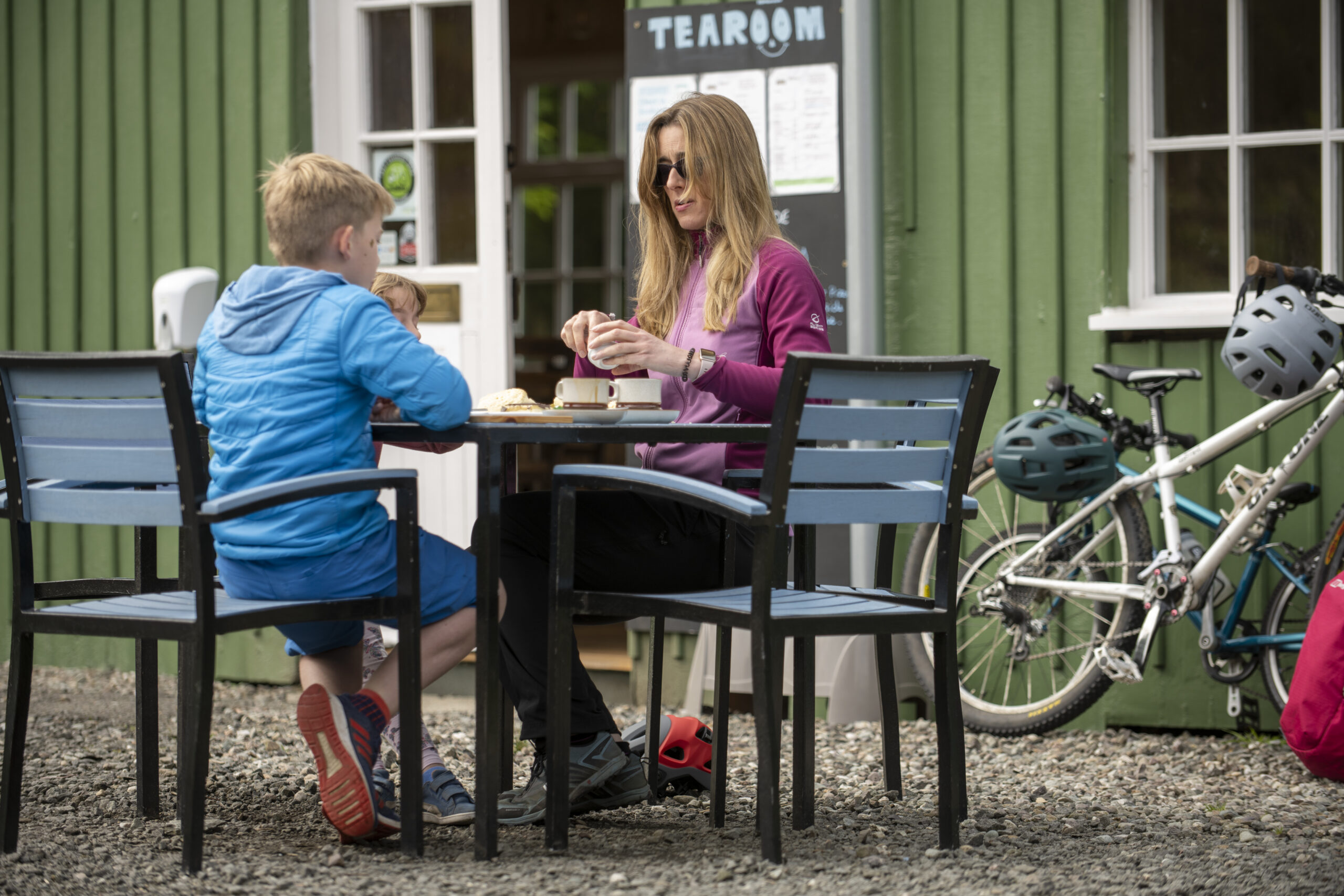
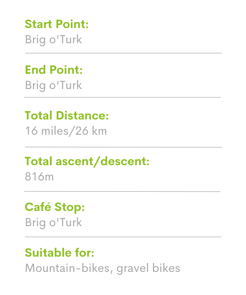
This circuit is well-renowned and gives a tough ride for experienced mountain bikers with plenty of stamina ‘in the bank’. Start and finish in Brig o’ Turk, west of Callander. Although the route might be considered ‘short’ by some, it still packs-in over 500m of climbing to the 600m contour.
Riders need to be fully aware of the following – parts of this loop are remote, exposed and without mobile ‘phone reception, please ensure you (and your bike) are in good condition before setting off.
Start in Brig o’ Turk between Callander and Loch Katrine. From Brig o’ Turk follow the road north for 1km to a fork – go right and follow the undulating farm track for 4.1km to another fork – go right.
The next 4.3km follows the Allt Gleanne nam Meann into the wild and atmospheric upper reaches of the valley – keep spinning up the 2.8km climb to a high point (cairn) and spectacular views of the surrounding mountains. The following 5.5km descent is easily worth the price of all the climbing, with steep ramps, sweeping bends and blistering speed down to the Finglas Water ford – enjoy. The next 2.4km section follows the undulating 4×4 track along Glen Finglas to the fork – turn right and head back into Brig o’ Turk for well-earned refreshments.


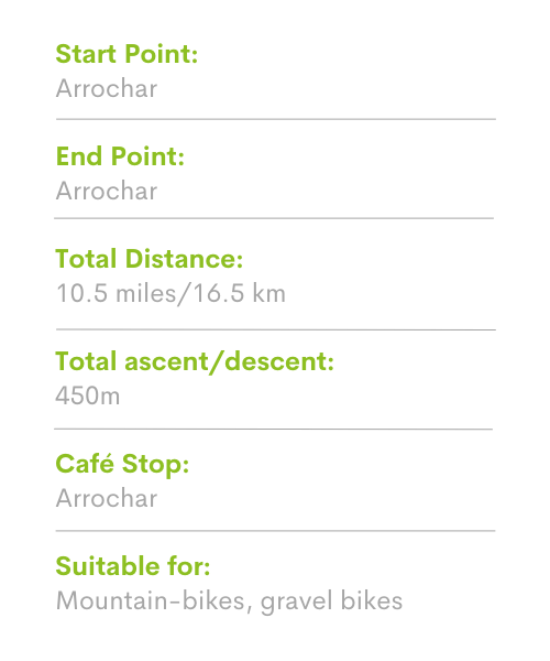
An awesome ride through the rugged splendour of the Arrochar Alps. Well-known to local riders, the circuit involves a long climb and stunning mountain scenery, followed by a fast descent and techy single track to finish. Starts / finish in Arrochar.
From the car park in Arrochar turn right, then left and follow the road through Succoth village to the forest entrance. The forest road climbs steadily through the conifers and contours around the triptych of Beinn Narnain (926m), Creag Tharsuinn (781m) and A’Chrois (849m) into the atmospheric Allt Coiregrogain. After crossing the stream, a sweeping 3.6km descent passes beneath the southern flank of Ben Vane (916m) – watch out for the occasional rough section.
Turn right towards Coiregrogain Farm. Cross the bridge over Inveruglas Water, turn immediately left and follow a section of joyous single-track weaving through the forest. A short, steep climb leads into fairly technical descent and more quality singletrack along Glen Loin. After the Stronafyne properties turn right then left and follow the Loin Water to the main road. Turn right and follow the road back to the car park.


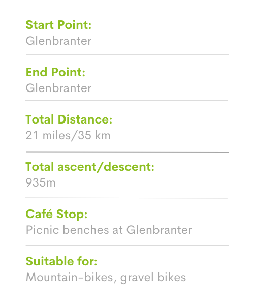
On a clear day, this demanding route reveals magnificent views of Loch Eck, Beinn Mhor and the west coast islands of Jura and Islay. Start / end at Glenbranter on the A815 in the Cowal Peninsula.
The loop starts/ends at the Forestry Commission Scotland centre at Glenbranter and is described in a counter clockwise direction.
Riders should be aware that although never technical, this is still a demanding ride through remote terrain in the high forests of eastern Loch Eck. Please ensure you (and your bike) are in good condition before setting off.
From Glenbranter, follow the track south to Glenshellish Farm, head left at the farm and towards the River Cur. The forest track heads along the western shore of Lock Eck for 11km to Benmore Botanical Gardens passing through peaceful forest and many tranquil beaches. Just before entering the gardens (cattle grid), turn left, head downhill to the bridge and cross into the car park /cafe. Cross the A815 (caution) to regain the waymarked path.
Follow the markers up a series of steep (but relatively short) singletrack climbs before rejoining the main forest track to head north. After a sweet section of singletrack around Inverchapel, follow the track for 6.1km, turn right at the Whistlefield Inn marker post and head uphill for 700m and then left to follow a short section of singletrack downhill, cross the unclassified road and head back into the forest. Climb a series of remote forest tracks via Coire Ealt and a rip-roaring descent to rejoin the A815. Turn right and follow the road for a short distance back to Glenbranter.